Features of Municipality of Castilla
Past & Present Municipal Mayor of Castilla

HON. OLIVIA M. BERMILLO
Municipal Mayor
2007 to Present

RENATO GIMPAYA LAURINARIA
Municipal Mayor
1998 - 2007

JOSEPH E.S. DARAMAN, JR.
Acting Municipal Mayor
1996 -1998

RENATO GIMPAYA LAURINARIA
Municipal Mayor
1998 - 2007

ANGEL C. VIBAL
Acting Municipal Mayor
Feb.01, 1984 -Apr. 18, 1986

ALEJANDRO G. LLADONES, SR.
Municipal Mayor
1967 - 1992

HERNANDO DELA PAZ
Municipal Mayor
1963 - 1967

DAVID GRIEGO
Municipal Mayor
1959 - 1963

RESTITUTA REBUENO
Municipal Mayor
1955 - 1959

RENATO GIMPAYA LAURINARIA
Municipal Mayor
1998 - 2007

Municipal Building Annex
Cumadcad, Castilla

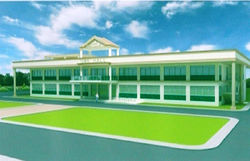
Municipal Building
Poblacion, Castilla
The seat of government is at the Poblacion, some 4.5 kilometers from the barangay Milagrosajunction along the national highway.But in 1968, during the administration of then Mayor Alejandro Lladones, the seat of municipal governance was moved to Cumadcad. Extending a semblance of legal basis for the transfer, councilor Bienvenido Marantal authored a resolution to the effect that transaction of official business could be facilitated due to accessibility.
The present municipal building in Cumadcad, described as annex, is said to be “strategically located” along the national highway, being midway between the province of Albay and Sorsogon downtown proper.
Physical Features
Location
Castilla which is hemmed in by hills, mountains, the 750-hectare PNOC forest reserve area on the north, and the Sorsogon Bay on the southern/eastern portion, occupies the western part of the Province of Sorsogon. In the east Castilla is bounded by Sorsogon proper and Sorsogon Bay; on the west by the Municipality of Pilar, on the north it is bounded by Manito, Albay; and on the south by Sorsogon Bay. Castilla is a coastal municipality at the province of Sorsogon which is located in the southern most of Luzon within coordinates 123 30' to 124 15' east longitude and from 12 30' to 13 15' north latitude. Farther south from the national highway are twelve coastal barangays along Sorsogon Bay. Salang-Buaya in Quirapi has the deepest sea-bed (8 to 9 fathoms) making it a most ideal commercial seaport. Occasional sightings of the world-famous Butandings in this area have been reported by fishermen. Malawmawan Island, hidden and unspoiled by tourists, is nearby beckoning nature-lovers with its very fine white sand beaches, corals, and rich marine resources. The seat of government is at the Poblacion, some 4.5 kilometers from the barangay Milagrosa junction along the national highway. But in 1968, during the administration of then Mayor Alejandro Lladones, the seat of municipal governance was moved to Cumadcad. Extending a semblance of legal basis for the transfer, councilor Bienvenido Marantal authored a resolution to the effect that transaction of official business could be facilitated due to accessibility.
Slope
The 34 barangays of Castilla fall under six(6) slope categories, namely:
-
0-30% which is characterized by board level
-
) 3.5% distinguished by gently sloping areas
-
) 5-8% Characterized by sloping lands
-
) 8-15% where undulating and gently rolling lands are found
-
) 15-18% Characterized by steeply undulating lands
-
) 18% And above distinguished by very sleep sloping and rolling lands in many directions
Majority of the Municipality's landfall under 0-31% slope with an approximate area of 11,270.30 hectares or 60.52% of the total land area. The 11 lowland Barangays fall under 8% and above category, which is gently, rolling lands to very steep rolling lands. The 10 upland barangays and part of the coastal barangays fall under this slope category.
Topography
Castilla has a varied and distinctively irregular topographic landscape. While the northern part and Southern portion along the coast are mountainous and hilly, the rest of the municipality level to nearly covering 11,270.30 hectares or 60.53% of its total land area. Irrigated rice fields sparsely occupy the lowlands while coconut abundantly covers the mountain slopes,hills and valleys and a number of tributaries that connect to Sorsogon Bay on the southern easthern part.
Geographic Location and Area
Castilla is a coastal municipality that lies on the northwestern part of the Province of Sorsogon. Hugging the northeastern portion of Sorsogon Bay, Castilla has geographic coordinates of 12 degrees 50 minutes and 17 seconds north to 13 degrees 2 munites and 35 seconds north latitude and 123 degrees 43 minutes and 58 seconds east to 123 degrees 52 minutes and 52 seconds east longitude. It is bounded on the north by the municipality of Manito,Albay Province ,on the south by Sorsogon bay, on the west by the Municipality of Pilarand on the east by Sorsogon City and part of Sorsogon Bay towards the southeast. Composed of 34 barangays,the Municipality of Castilla has a total land area of 18,620.30 hectares which 8.71% of the total land area of the Province of Sorsogon.Ten of its 34 barangays are upland while the remaining 11 and 13 barangays are lowland and coastal respectively. There are only three (3) urban Baranagys, namely, Cumadcad, Poblacion and Macalaya, while the rest classified as rural areas. In terms of land Area,BarangayMilagrosa is the Largest which is about 1,343.90 hectares while the smallest is barangay Saclayan with a land Area of about 120 hectares. Using the Milagrosa crossing as point of reference,Castilla is 38km from the regional center of Legazpi City and 22km from the city proper of Sorsogon. The present town center of Cumadcad which is strategically located between the Provinces of Albay and Sorsogon is about 573 km from manila.
Climate
The western side of the Bicol Peninsula belongs to type IV Climate based on Coronas Modified Classification as used by the Philippine Atmospheric Geophysical and Astronomical Services Administration (PAGASA). This type of climate is characterized by rainfall being more or less evenly distributed throughout the years.
The nearest climatological station of PAGASA to Castilla is the Legazpi monitoring station which is located between the observed boundary of the Type III and type IV climates (climate Map of the Philippines, NWRB). However, there is a slight difference in rainfall in Castilla that being more of a type IV, the same climatological data observed in Legazpi is hence applied in Castilla. Based on a 30 years record form PAGASA synoptic station in Legazpi, the area receives as annual rainfall of about 3,846 mm.
Temperature in the town changes within a limited range between 2.5 degrees only. The average annual temperature in the town is 27.210c. The period December to February is the coolest with mean temperature of about 26.90c. On the other hand, the warmest month is May with mean temperature of 28.50c.
The average relative humidity in the city is about 86% with a range of 83% to 90%. High relative humidity commonly occurs between November to December while low humidity is usually experiences the month of May.
 |  |
|---|---|
 |
